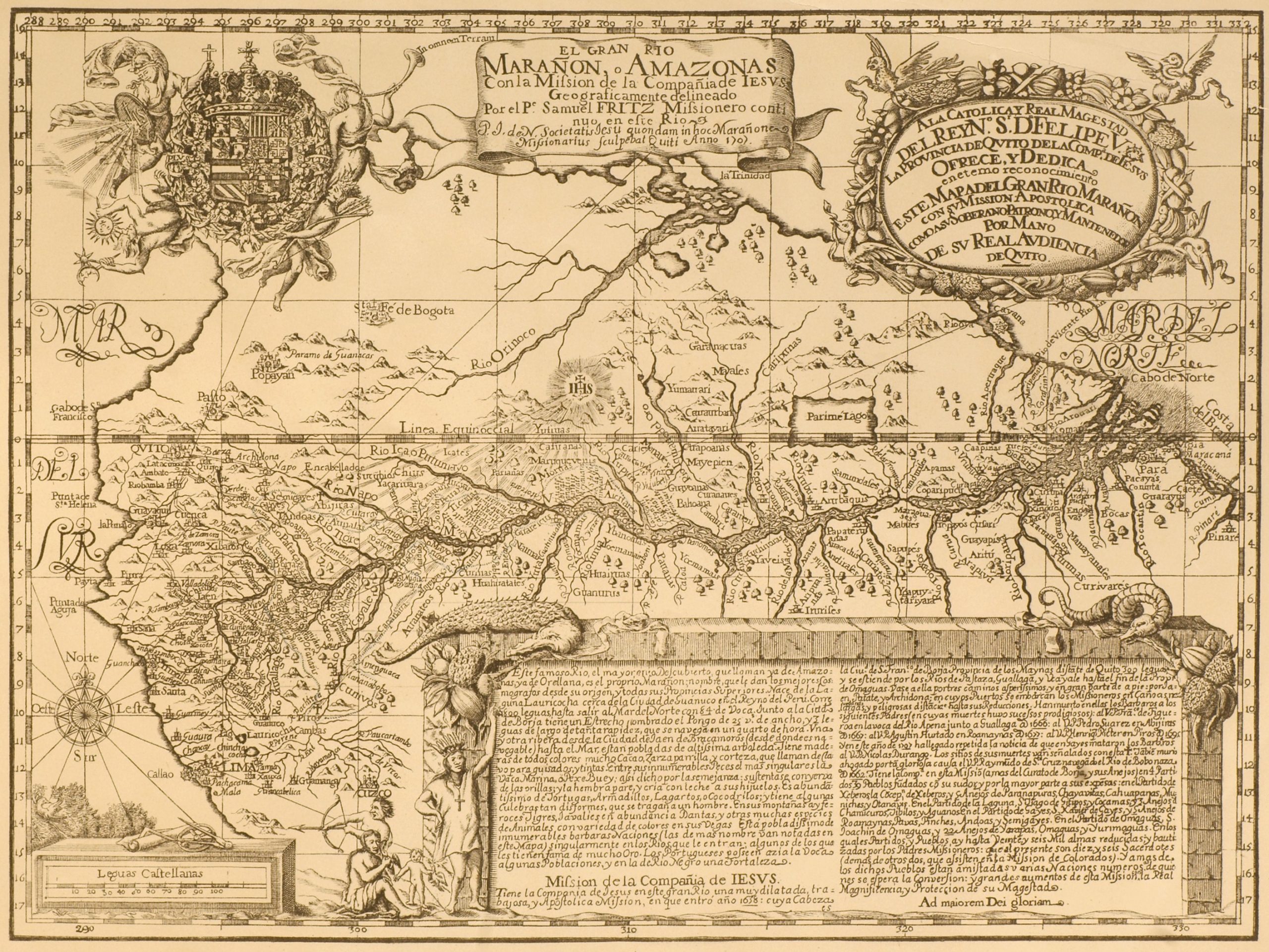
Our current vision of the Amazon River was pioneered by Samuel Fritz. A member of the Society of Jesus, he left his native Bohemia – today’s Czechia — for South America in 1686 and remained in the Jesuit province of Quito, today’s Ecuador, until 1725. Fritz is perhaps best known for authoring a map of the Amazon River, engraved in Quito in 1707. As an object of knowledge, scholars have praised Fritz’s map for its detailed ethnographic and scientific information and, interestingly, as one of the silenced sources of the Frenchman Charles- Marie de la Condamine, head of the scientific exploration to the Amazon River and author of a map and travel account of the region, Relation abrégée d’un voyage fait dans l’intérieur del’Amérique méridionale. An unattended aspect of Fritz’s map, however, was its objective to amend European and specifically Portuguese longitudinal representations of the Amazon with a view that privileged its Peruvian headwaters.
Fritz map of Amazon
S. Fritz, ‘The Marañon or Amazon River, with the Jesuit Mission’, 1707 (courtesy of the Archivo del Ministerio de Relaciones Exteriores de Ecuador).
1707
Roberto Chauca Tapia
Further reading
- de Almeida, A.F. (2003) ‘Samuel Fritz and the mapping of the Amazon’, Imago Mundi, vol. 55, 113–19
- de Almeida, A.F. (2003) ‘Samuel Fritz revisited: the maps of the Amazon and their circulation in Europe’, in La cartografia europea tra Primo Rinascimento e fine dell’Illuminismo, edited by Ramada Curto, A. Cattaneo, and A.F. de Almeida, 133–53 (Florence: Leo S. Olschki).
- Burgos, H. (2005) La crónica prohibida: Cristóbal de Acuña en el Amazonas (Quito: FONSAL).
- Dias, C. (2012) ‘Jesuit maps and political discourse: the Amazon River of Father Samuel Fritz’, The Americas, 69 (1): 95–116.
- Fernández-Salvador, C. (2014) ‘Jesuit missionary work in the imperial frontier: mapping the Amazon in seventeenth-century Quito’, in Religious Transformations in the Early Modern Americas, edited by S. Kirk and S. Rivett, 205– 27 (Philadelphia, PA: University of Pennsylvania Press).
- Fritz, S. (1922) Journal of the Travels and Labours of Father Samuel Fritz in the River of the Amazons between 1686 and 1723, translated and edited by Edmunson (London: Hakluyt Society).
- Langer, P. (2009) ‘Cartas geográficas edificantes: o imaginário da conversão dos povos indígenas nos mapas dos jesuítas Heinrich Scherer e Samuel Fritz’, in Conversão dos cativos: povos indígenas e missão jesuítica, edited by P. Suess, B. Melià, J.O. Beozzo, B. Prezia, G. Chamorro, and P. Langer, 79–90 (São Bernardo do Campo: Nhanduti).
- Latorre, O. (1988) Los mapas del Amazonas y el desarrollo de la cartografía ecuatoriana en el siglo XVIII (Guayaquil: Museos del Banco Central del Ecuador).
- Lucero, I. (2004) ‘La cartografía de la antigua provincia de Quito de la Compañía de Jesús’, STL thesis (Boston, MA: Weston Jesuit School of Theology).
- Safier, N. (2008) Measuring the New World: Enlightenment Science and South America (Chicago, IL: University of Chicago Press).


