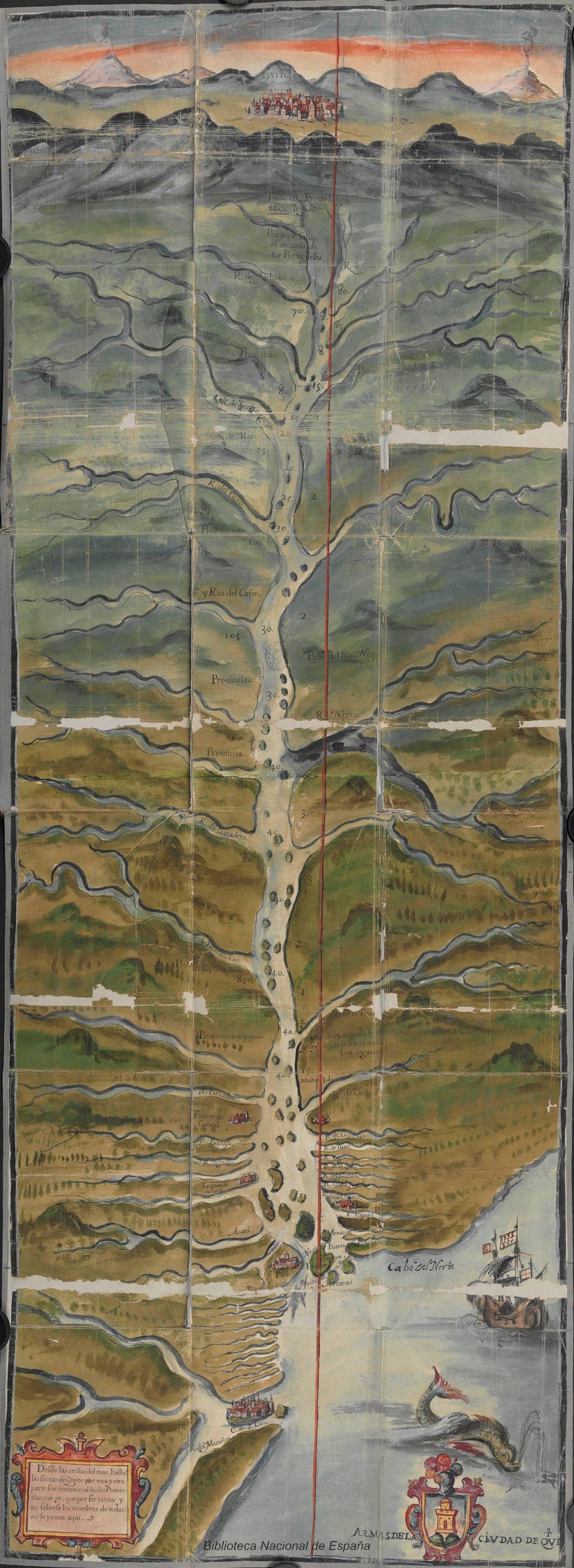
This 1639 map portrays the Amazon with a peculiar longitudinal orientation, with the city of Quito at the top at the headwaters of the river. The chart lent support to the development and advancement of Portuguese Jesuit missionary activity along the course of the Amazon. The cartographic delineation of the Amazon River in a longitudinal or north–south orientation was the foundation of the ‘Brazil-as-island’ concept. The implication of ths concept was that both crowns could exert dominion along the entire Amazon and River Plate, since the rivers constituted the very line dividing the Portuguese and Spanish realms in South America. As a result, the maps of South America produced by some of the most renowned cartographers had to be contested from the Spanish side, since this delineation gave a free pass to Portuguese and other Atlantic powers to navigate upriver towards the sources of the Amazon and River Plate to the Viceroyalty of Peru, including the silver mines of Potosí.
BRAZIL-AS-ISLAND MAP
Anonymous, Mapa del río Amazonas y su cuenca, in Martín de Saavedra, Descubrimiento del Río Amazonas y sus dilatadas provincias, 1639 (courtesy of the Biblioteca Nacional de España).
1639
Roberto Chauca Tapia
Further reading
- de Almeida, A.F. (2003) ‘Samuel Fritz and the mapping of the Amazon’, Imago Mundi, vol. 55, 113–19
- de Almeida, A.F. (2003) ‘Samuel Fritz revisited: the maps of the Amazon and their circulation in Europe’, in La cartografia europea tra Primo Rinascimento e fine dell’Illuminismo, edited by Ramada Curto, A. Cattaneo, and A.F. de Almeida, 133–53 (Florence: Leo S. Olschki).
- Burgos, H. (2005) La crónica prohibida: Cristóbal de Acuña en el Amazonas (Quito: FONSAL).
- Dias, C. (2012) ‘Jesuit maps and political discourse: the Amazon River of Father Samuel Fritz’, The Americas, 69 (1): 95–116.
- Fernández-Salvador, C. (2014) ‘Jesuit missionary work in the imperial frontier: mapping the Amazon in seventeenth-century Quito’, in Religious Transformations in the Early Modern Americas, edited by S. Kirk and S. Rivett, 205– 27 (Philadelphia, PA: University of Pennsylvania Press).
- Fritz, S. (1922) Journal of the Travels and Labours of Father Samuel Fritz in the River of the Amazons between 1686 and 1723, translated and edited by Edmunson (London: Hakluyt Society).
- Langer, P. (2009) ‘Cartas geográficas edificantes: o imaginário da conversão dos povos indígenas nos mapas dos jesuítas Heinrich Scherer e Samuel Fritz’, in Conversão dos cativos: povos indígenas e missão jesuítica, edited by P. Suess, B. Melià, J.O. Beozzo, B. Prezia, G. Chamorro, and P. Langer, 79–90 (São Bernardo do Campo: Nhanduti).
- Latorre, O. (1988) Los mapas del Amazonas y el desarrollo de la cartografía ecuatoriana en el siglo XVIII (Guayaquil: Museos del Banco Central del Ecuador).
- Lucero, I. (2004) ‘La cartografía de la antigua provincia de Quito de la Compañía de Jesús’, STL thesis (Boston, MA: Weston Jesuit School of Theology).
- Safier, N. (2008) Measuring the New World: Enlightenment Science and South America (Chicago, IL: University of Chicago Press).


